
Johnston, Alexander Keith
Søgeresultater
29 bøger fra Johnston, Alexander Keith

THE HANDY ROYAL ATLAS OF MODERN GEOGRAPHY. Exhibiting the Present Condition of Geographical Discovery and Research in the Several Countries, Empires, and States of the World. By the Late ... With Additions and Corrections to the Present Date by G.H. Johnston.
Johnston, Alexander Keith. · 1913 · Francis Edwards Booksellers
£450.00 (€538.83 | $596.89 | ¥95,381)
W & A K Johnston 1913. 4to. [iv] + 84pp. 61 double page maps. From the Library of Jerrold Northrop Moore, light age toning, dec. e.ps. (sl. spotted), gilt rule edged half morocco with gilt lettered cloth boards, some marking to cloth, gilt ruling and lettering to spine, sl. r...
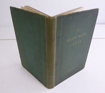
The Handy Royal Atlas of Modern Geography. (Dedicated to Edward, Prince of Wales). Original Edition
Johnston, Alexander Keith (1804 - 1871); Introduction by T. Alford Smith · 1927 · Wittenborn Art Books
$250.00 (€225.68 | £188.48 | ¥39,949)
Edinburgh : W. & A.K. Johnston, Limited, and London: MacmIllan & Co. 1927. Folio. 25 x 37.3cm. Original green cloth, worn along edges.. [10], 120, [2], 56pp.Colour maps. OCLC Number / Unique Identifier: 1569489994: Contents: North Polar chart; Chart of the World, on Mercator's...

Europe (Map)
Alexander Keith Johnston · 1871 · Wittenborn Art Books
$50.00 (€45.14 | £37.70 | ¥7,990)
Edinburgh: William Blackwood and Sons, [1871]. Folded, hand-colored map of Europe, showing German Empire after the war with France. 18 x 14 inches. Good. Some toning from age. Two inch tear along fold at bottom center. Engraved and printed by W & A. K. Johnston. Alexander Keit...

The Physical Atlas of Natural Phenomena
Johnston Alexander Keith · 1850 · George Jeffery Books
£325.00 (€389.16 | $431.09 | ¥68,886)
William Blackwood & Sons Book measures 37x30.cm. 122,[2]pp, double page frontis, plus 24 maps, all coloured. Bound in period full calf, ornate gilt dentells, raised bands, gilt tooling to spine, full gilt edges, marble endpapers. Calf rubbed, worn, top board detached. Would be...

A monumental twelve inch Terrestrial globe
Johnston, William & Alexander Keith|Terrestrial Library Globe · 1878 · Antiquariaat de Roo (NVvA)
€7,500.00 ($8,308.12 | £6,263.54 | ¥1,327,602)
Edinburgh, W & A.K. Johnston 1878 A small terrestrial library globe, more than a hundred years old, with the known world in the middle of the 19th century. The globe is mounted in a calibrated brass meridian with an hour ring on the north pole and a wooden horizon ring with th...

A fine and impressive Terrestrial library globe
Johnston, William & Alexander Keith|Terrestrial Library Globe · 1861 · Antiquariaat de Roo (NVvA)
€17,500.00 ($19,385.62 | £14,614.93 | ¥3,097,738)
Edinburgh, W & A.K. Johnston 1861 Johnston's Eighteen-inch Terrestrial globe containing the latest Geographical Discoveries The globe is mounted in a calibrated brass meridian with an hour ring on the north pole and a wooden horizon ring with the houses of the zodiac, the mont...

Handy Royal Atlas of Modern Georgrahy [ 51 Double Page Coloured Maps ]
Johnston Alexander Keith · 1892 · George Jeffery Books
£125.00 (€149.68 | $165.80 | ¥26,495)
W & A. K. Johnston & Publishers Book measures 38x27.cm. 51 double page coloured maps, plus index. Bound in original publishers half calf, calf corners, raised bands, gilt crest and lettering. Binding heavily worn, hinge joints split, binding holding. Internally, pages, maps in...
[FRAMED GLAZED MAP OF] AUSTRO-HUNGARIAN MONARCHY. (Western Sheet) Inset Map of Continuation of Dalmatia & Herzegovina On Same Scale. Inset plan of Vienna (Wien) and its Environs. Showing Railways and Canals. Sites of Battles 1809. Heights in English Feet. 10 scales.
Johnston, Alexander Keith. · 1883 · Francis Edwards Booksellers
£30.00 (€35.92 | $39.79 | ¥6,359)
Engraved Printed and Published by W. & A.K. Johnston Edinburgh 1883. Coloured in outline, light central crease, glazed using acrylic with pine frame, measuring 65cm x 53cm including frame, in very good order. From ‘The Royal Atlas of Modern Geography’ Exhibiting in a Series o...
[FRAMED GLAZED MAP OF] INDIA (Southern Sheet) With an inset map of the South-Eastern Provinces of India (Hindu Chinese Countries or Further India). Including Ceylon and the Lakkadiv Islands, Andaman and Nicobar Islands. British Territory tinted Red, Protected States Yellow. Showing Railways and Canals. Sites of Battles 1803. Heights in English Feet. Sub Telegraph lines shown in blue. 6 scales.
Johnston, Alexander Keith. · 1883 · Francis Edwards Booksellers
£30.00 (€35.92 | $39.79 | ¥6,359)
Engraved Printed and Published by W. & A.K. Johnston Edinburgh 1883. Coloured in outline, light central crease, glazed using acrylic with pine frame, measuring 65cm x 53cm including frame, in very good order. From ‘The Royal Atlas of Modern Geography’ Exhibiting in a Series o...
[FRAMED GLAZED MAP OF] DENMARK With North-West Portion of the German Empire comprising Schleswig-Holstein, Hanover, Brunswick, Mecklenburg. Oldenburg, Amhalt, Lippe &c. With inset maps of Iceland, Faroe Islands, Copenhagen, and Bornholm. Showing Railways and Canals. Heights in English Feet. Sub Telegraph lines and Sea Routes in blue. 5 scales.
Johnston, Alexander Keith. · 1883 · Francis Edwards Booksellers
£25.00 (€29.94 | $33.16 | ¥5,299)
Engraved Printed and Published by W. & A.K. Johnston Edinburgh 1883. Coloured in outline, light central crease, glazed using acrylic with pine frame, measuring 53cm. x 65cm including frame, in very good order. From ‘The Royal Atlas of Modern Geography’ Exhibiting in a Series ...
[FRAMED GLAZED MAP OF] TURKEY IN EUROPE. With Rumania, Servia, Montenegro Bulgaria &c. Inset maps of Crete and Bosphorus & Constantinople. Showing Railways. Sites of Battles 1853. Heights in English Feet. Sub Telegraph lines in blue. 5 scales.
Johnston, Alexander Keith. · 1883 · Francis Edwards Booksellers
£40.00 (€47.90 | $53.06 | ¥8,478)
Engraved Printed and Published by W. & A.K. Johnston Edinburgh 1883. Coloured in outline, light central crease, glazed using acrylic with pine frame, measuring 65cm x 53cm including frame, in very good order. From ‘The Royal Atlas of Modern Geography’ Exhibiting in a Series o...
[FRAMED GLAZED MAP OF] BELGIUM AND THE NETHERLANDS. Including Western Rhenish Prussia and Westphalia. Showing Railways, Canals, Marsh & Heathland, Forests. Sites of Battles 1815. Sub Telegraph lines in blue. 4 scales.
Johnston, Alexander Keith. · 1883 · Francis Edwards Booksellers
£25.00 (€29.94 | $33.16 | ¥5,299)
Engraved Printed and Published by W. & A.K. Johnston Edinburgh 1883. Coloured in outline, light central crease, glazed using acrylic with pine frame, measuring 65cm x 53cm including frame, in very good order. From ‘The Royal Atlas of Modern Geography’ Exhibiting in a Series o...
Index Geographicus. Being a List Alphabetically Arranged of the Principal Places on the Globe with the Countries and Subdivions of the Countries in which they are Situated and their Latitudes and Longitudes
Johnston, Alexander Keith · 0 · Barter Books Ltd
£28.00 (€33.53 | $37.14 | ¥5,935)
G : in good condition without dust jacket. Spine Coverlon covered Edinburgh William Blackwood & Sons First edition thus 260mm x 170mm (10" x 7"). 676pp. Compiled specially with reference to Keith Johnston's Royal Atlas. Heavy book extra shipping needed for overseas.
Royal Atlas of Modern Geography. Exhibiting in a Series of Entirely Original and Authentic Maps, the Present Condition of Geographical Discovery and Research in the Several Countries, Empires, and States of the World. With Index Geographicus. 2 volume set
Johnston, Alexander Keith · 1861 · Barter Books Ltd
£760.00 (€910.03 | $1,008.08 | ¥161,087)
G : in good condition. Cover rubbed with edgewear. Content in very good condition Edinburgh William Blackwood & Sons First Edition 260mm x 170mm (10" x 7"). ix, [124pp] + maps; 676pp. 48 double-page colour maps. Index published 1864. Index volume Ex-lib. in black library bindi...
The Physical Atlas of Natural Phenomena, for the Use of Colleges, Academies, and Families
Johnston, Alexander Keith · 1850 · Kevin Mullen, Bookseller
$375.00 (€338.52 | £282.71 | ¥59,923)
Philadelphia, Lea and Blanchard, 1850. Hardcover. Navy blue buckram, gilt letters on spine, 122 text pp. 24 colored map plates. plus double-page colored map as frontispiece. A terrific copy of Johnston's early physical atlas, although in rebound form. This copy once belonged t...
The Modern County Atlas Of England And Wales
Johnston, William And Alexander, Keith · 1889 · Clarendon Books P.B.F.A.
£145.00 (€173.62 | $192.33 | ¥30,734)
W. & A. K. Johnston Later green cloth in good condition, rubbed and a little worn in places, general map with 57 single and double page county maps, 62pp index, small split to the general map and one other loose from it's hinge Edinburgh Good 4to - over 9¾" - 12" tall

Zoological Geography - Division, Distribution and Types of Gnawing and Ruminating Animals
Alexander Keith Johnston · 1848 · Bailgate Books Ltd
£36.00 (€43.11 | $47.75 | ¥7,630)
Map William Blackwood & Sons, Edinburgh and London, 1848. First Edition, Softcover, Illustrated by: Engraved by W & A K Johnston. Very Good Condition/No Dust Jacket. Disbound map with two sheets of accompanying notes from "The Physical Atlas, A Series of Maps & Notes Illustrat...
Map showing Survey of the Geographical Distribution and Cultivation of the most Important Plants which are used as Food for Man
Alexander Keith Johnston · 1848 · Bailgate Books Ltd
£32.00 (€38.32 | $42.45 | ¥6,783)
Map William Blackwood & Sons, Edinburgh and London, 1848. First Edition, Softcover, Illustrated by: Engraved by W & A K Johnston. Very Good Condition/No Dust Jacket. Disbound map with single sheet of accompanying notes from "The Physical Atlas, A Series of Maps & Notes Illustr...
Hyetographic or Rain Map of Europe from the Drawings of Professor Berghaus
Alexander Keith Johnston · 1848 · Bailgate Books Ltd
£32.00 (€38.32 | $42.45 | ¥6,783)
Map William Blackwood & Sons, Edinburgh and London, 1848. First Edition, Softcover, Illustrated by: Engraved by W & A K Johnston. Very Good Condition/No Dust Jacket. Disbound map with single sheet of accompanying notes from "The Physical Atlas, A Series of Maps & Notes Illustr...
Hyetographic or Rain Map of the World Extended from the Original Designs of Professor Berghaus
Alexander Keith Johnston · 1848 · Bailgate Books Ltd
£32.00 (€38.32 | $42.45 | ¥6,783)
Map William Blackwood & Sons, Edinburgh and London, 1848. First Edition, Softcover, Illustrated by: Engraved by W & A K Johnston. Very Good Condition/No Dust Jacket. Disbound map with one sheet of accompanying notes from "The Physical Atlas, A Series of Maps & Notes Illustrati...