
Småtryk
Småtryk, postkort, plakater og trykte memorabilia.
Søgeresultater
45746 bøger i Småtryk

Right of Way and Track Map of Davis Creek, Garret, Alturas, Modoc County, Ca
Southern Pacific Lines (San Francisco, Calif.) · 1952 · Wittenborn Art Books
$350.00 (€317.55 | £264.92 | ¥55,873)
San Francisco, Calif.: Southern Pacific Company, 1952. Blueline print, 24 inches x 55 inches. From approx 5 miles south of Station Point Davis Creek to approx 2 miles north of abandoned Station Point Garret. No structures indicated, extensive listing of signal and track measur...

Right of Way and Track Map of Alturas, Modoc County, California
Southern Pacific Lines (San Francisco, Calif.) · 1952 · Wittenborn Art Books
$350.00 (€317.55 | £264.92 | ¥55,873)
San Francisco, Calif.: Southern Pacific Company, 1952. Blueline print, 24 inches x 55 inches. From Alturas to California-Oregon State Line along railroad tracks and North Fork of Pitt River. No structures indicated, extensive listing of signal and track measurements. With Sche...
Right of Way and Track Map of Alturas, Modoc County, Ca
Southern Pacific Lines (San Francisco, Calif.) · 0 · Wittenborn Art Books
$350.00 (€317.55 | £264.92 | ¥55,873)
San Francisco, Calif.: Southern Pacific Company, [n.d.]. Blueline print, 24 inches x 55 inches. From approx 2 miles south of North fork of Pitt River to outer city limits of Alturas. With all streets along tracks in Alturas. Scale 1 inch = 400 feet. .
Right of Way and Track Map of Albany, Linn County, Ore
Southern Pacific Lines (San Francisco, Calif.) · 0 · Wittenborn Art Books
$350.00 (€317.55 | £264.92 | ¥55,873)
Portland, Ore.: Southern Pacific Company, [n.d.]. Blueline print, 24 inches x 55 inches. From Isaac Hutchins Donation Land Claim at southwest corner of Albany to Exum Powell claim beyond 2nd standard Parallel south. With Williamette River, all streets within Albany city limits...

Right of Way and Track Map of Albany and Page, Linn County, Ore
Southern Pacific Lines (San Francisco, Calif.) · 1870 · Wittenborn Art Books
$350.00 (€317.55 | £264.92 | ¥55,873)
Portland, Ore.: Southern Pacific Company, [n.d.]. Blueline print, 24 inches x 55 inches. From Station Point Page to approximate 3 miles south. With Isaac Hutchins Donation Land Claim, Leonidas McFarland donation claim. Includes Schedule of Property listing 8 transfers, 1870-18...

Right of Way and Track Map of Antioch, Jersey, Newlove, and Neroly, Contra Costa County, Ca
Southern Pacific Lines (San Francisco, Calif.) · 1960 · Wittenborn Art Books
$350.00 (€317.55 | £264.92 | ¥55,873)
San Francisco, Calif.: Southern Pacific Company, 1960. Blueline print, 24 inches x 55 inches. From Abbot & Beade tract in Antioch to 4000 feet east of Station Point Neroly. With Frank Peabody's Subdivision, Associated Pipe Line Company. Includes Schedule of Property listing ap...

Right of Way and Track Map of Los Medanos and Antioch, Contra Costa County, Ca
Southern Pacific Lines (San Francisco, Calif.) · 1959 · Wittenborn Art Books
$350.00 (€317.55 | £264.92 | ¥55,873)
San Francisco, Calif.: Southern Pacific Company, 1959. Blueline print, 24 inches x 55 inches. From 4000 feet west of Station Point Los Medanos to Cakebread Lake, Antioch City Limit. Streets near track in Antioch listed, no buildings indicated. Includes Schedule of Property lis...

Right of Way and Track Map of Auburn, Sacramento County, Ca
Southern Pacific Lines (San Francisco, Calif.) · 1956 · Wittenborn Art Books
$350.00 (€317.55 | £264.92 | ¥55,873)
San Francisco, Calif.: Southern Pacific Company, 1956. Blueline print, 24 inches x 55 inches. Both tracks through Auburn detailed in full. Includes Station points Auburn - Nevada Street, Auburn, abandoned station Flint. With some structures along track in downtown. Scale 1 inc...

Right of Way and Track Map of Sierra Vista and Minturn, Merced County, Ca
Southern Pacific Lines (San Francisco, Calif.) · 1956 · Wittenborn Art Books
$350.00 (€317.55 | £264.92 | ¥55,873)
San Francisco, Calif.: Southern Pacific Company, 1956. Blueline print, 24 inches x 55 inches. From northwestern tip of Sierra Lands development to Ash Slough. With Sierra Vista Lands Subdivisions, Chowchilla River. Includes Schedule of Property listing approx 20 transfers, 187...

Right of Way and Track Map of Fairmead, Madera County, Ca
Southern Pacific Lines (San Francisco, Calif.) · 1961 · Wittenborn Art Books
$350.00 (€317.55 | £264.92 | ¥55,873)
San Francisco, Calif.: Southern Pacific Company, 1961. Blueline print, 24 inches x 55 inches. From Riverside Street and Second Street in Dairyland to Broadway and Sixth Street in Califa Home Tract. Includes Ten Tree Tract, Fairmead Colony. Scale 1 inch = 400 feet. .

Right of Way and Track Map of Benecia and Army Point, Solano County, Ca
Southern Pacific Lines (San Francisco, Calif.) · 0 · Wittenborn Art Books
$350.00 (€317.55 | £264.92 | ¥55,873)
San Francisco, Calif.: Southern Pacific Company, [n.d.]. Blueline print, 24 inches x 55 inches. From Contra Costa County Line past Benecia along railroad tracks to 4000 feet beyond edge of Army Point. With US Military Reservation Land, Suisun Bay. Scale 1 inch = 400 feet. Incl...
Right of Way and Track Map, San Jose to Vasona, Santa Clara County, Ca
Southern Pacific Lines (San Francisco, Calif.) · 1942 · Wittenborn Art Books
$350.00 (€317.55 | £264.92 | ¥55,873)
San Francisco, Calif.: Southern Pacific Company, 1942, rev. 1960. Blackline print, 24 inches x 55 inches. From Kearney Street and Park Avenue to 4000 feet beyond Fruitvale Avenue, along railroad track. With San Jose Brick Company, Sainsevaine Villa. With Schedule of Property l...
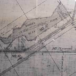
Right of Way and Track Map, San Jose to Vasona, Santa Clara County, Ca
Southern Pacific Lines (San Francisco, Calif.) · 1960 · Wittenborn Art Books
$350.00 (€317.55 | £264.92 | ¥55,873)
San Francisco, Calif.: Southern Pacific Company, 1960. Blackline print, 24 inches x 55 inches. From Barstow Tract past Los Gatos Creek and railroad tracks to Pollard Road in Vasona. Includes Vasona, Campbell, Los Gatos Creek, gravel beds. With Schedule of Property listing appr...
Right of Way and Track Map of Millbrae, San Mateo County, Ca
Southern Pacific Lines (San Francisco, Calif.) · 0 · Wittenborn Art Books
$350.00 (€317.55 | £264.92 | ¥55,873)
San Francisco, Calif.: Southern Pacific Company, [n.d.]. Blackline print, 24 inches x 55 inches. From Garcia Avenue to Lincoln Avenue along Hemlock Avenue and California Drive. With Millbrae, Burlingame Gate, Bayside Manor, Millsdale Industrial Park. Scale 1 inch = 200 feet. .
Right of Way and Track Map of Burbank, Los Angeles County, Ca
Southern Pacific Lines (San Francisco, Calif.) · 0 · Wittenborn Art Books
$350.00 (€317.55 | £264.92 | ¥55,873)
San Francisco, Calif.: Southern Pacific Company, [n.d.]. Blackline print, 24 inches x 55 inches. From Vineland Avenue to Victory Boulevard between Burbank Boulevard and Magnolia Boulevard. Includes Rancho Ex-Mission de San Fernando, Rancho Providencia, Rancho San Rafael. Scale...

Right of Way and Track Map of Burbank, Los Angeles County, Ca
Southern Pacific Lines (San Francisco, Calif.) · 0 · Wittenborn Art Books
$350.00 (€317.55 | £264.92 | ¥55,873)
San Francisco, Calif.: Southern Pacific Company, [n.d.]. Blackline print, 24 inches x 56 inches. From Empire Avenue beyond Buena Vista Street to beyond Center Street and Burbank Boulevard. Includes Lockheed Aircraft Corporation, Providencia, Rancho San Rafael. Scale 1 inch = 2...
Right of Way and Track Map of Butte County, Ca
Southern Pacific Lines (San Francisco, Calif.) · 1934 · Wittenborn Art Books
$350.00 (€317.55 | £264.92 | ¥55,873)
San Francisco, Calif.: Southern Pacific Company, 1934. Blackline print, 24 inches x 55 inches. No structures or industries indicated, map consists primarily of railroad track signals and measurements. With Schedule of Property indicating approx 10 transfers, 1866-1934. Scale 1...

Right of Way and Track Map of West Glendale and Glendale, Los Angeles County, Ca
Southern Pacific Lines (San Francisco, Calif.) · 0 · Wittenborn Art Books
$350.00 (€317.55 | £264.92 | ¥55,873)
San Francisco, Calif.: Southern Pacific Company, [n.d.]. Blackline print, 24 inches x 55 inches. From Glendale Boulevard and Irving Avenue to Brand Boulevard and Fernando Road. Includes Rancho San Rafael, Rancho Los Felis, West Glendale, Glendale. Scale 1 inch = 400 feet. .

Right of Way and Track Map of Chico and Vicinity, Butte County, Ca
Southern Pacific Lines (San Francisco, Calif.) · 1960 · Wittenborn Art Books
$350.00 (€317.55 | £264.92 | ¥55,873)
San Francisco, Calif.: Southern Pacific Company, 1960. Blackline print, 24 inches x 55 inches. From Diamond Match Company at Stirling City Bridge to beyond Chico Vecino. Diamond Match buildings detailed. Includes Schedule of Property listing approx 35 transfers, 1866-1960. Sca...

Right of Way and Track Map of Vega and Vicinity, Los Angeles, Los Angeles County, Ca
Southern Pacific Lines (San Francisco, Calif.) · 1961 · Wittenborn Art Books
$350.00 (€317.55 | £264.92 | ¥55,873)
San Francisco, Calif.: Southern Pacific Company, 1961. Blackline print, 24 inches x 55 inches. From Tujunga Avenue to Empire Avenue and Hollywood Way, along Van Owen Street. With Includes Schedule of Property listing approx 40 transfers, 1902-1961. Scale 1 inch = 200 feet. .