
Småtryk
Småtryk, postkort, plakater og trykte memorabilia.
Søgeresultater
45746 bøger i Småtryk

Industry Map of Santa Clara - San Jose, California
Southern Pacific Lines (San Francisco, Calif.) · 1947 · Wittenborn Art Books
$250.00 (€226.82 | £189.23 | ¥39,909)
San Francisco, Calif.: Southern Pacific Company, 1947, revised 1963. Map. Blueline print 15.5" x 39". From Milpitas to Oak Grove and Alamitos. Includes Wayne, College Park, Shell Oil Co, Municipal Airport, Agnew State Hospital. With Index to Industries with approx. 700 entries...

Industrial Map of Luther, Santa Clara County, California
Southern Pacific Lines (San Francisco, Calif.) · 1938 · Wittenborn Art Books
$350.00 (€317.55 | £264.92 | ¥55,873)
San Francisco, Calif.: Southern Pacific Company, 1938, revised 1944. Map. Blueline print 24" x 56" From WP crossing to Luther. Includes Monarch Match Co, Levin Machinery and Salvage Co, California Concrete Products Co. Scale 1" = 100'. .

Industrial Map of San Jose, Alameda County, California
Southern Pacific Lines (San Francisco, Calif.) · 1944 · Wittenborn Art Books
$375.00 (€340.23 | £283.84 | ¥59,864)
San Francisco, Calif.: Southern Pacific Company, 1944. Map. Blueline print 51" x 52" Multiple maps have been cut and joined with glue, red ink indicating railroad lines, switching points, and switching limits cross map joints. No Index to Industry is included, but many industr...

Proposed Track Map of San Jose, Alameda County, California. Dresser, Farwell, Brightside
Southern Pacific Lines (San Francisco, Calif.) · 1950 · Wittenborn Art Books
$350.00 (€317.55 | £264.92 | ¥55,873)
San Francisco, Calif.: Southern Pacific Company, 1950. Map. Blueline print 24" x 73". Includes station points at Dresser, Farwell, and Brightside. Includes Schedule of Property listing approx. 10 transfers, 1870-1950, with additional notes from U.S. Land Office Records, 1868-1...

Proposed Track Map of Milpitas, California
Southern Pacific Lines (San Francisco, Calif.) · 1953 · Wittenborn Art Books
$350.00 (€317.55 | £264.92 | ¥55,873)
San Francisco, Calif.: Southern Pacific Company, 1953. Map. Blueline print 24" x 73", with red pencil notation. Title indicates "Proposed trackage to serve Ford Motor Company." Scale 1" = 200' With inset regional map, scale 1" = 1000'. .

Right of Way and Track Map of Sunol, San Jose, Alameda County, California
Southern Pacific Lines (San Francisco, Calif.) · 1945 · Wittenborn Art Books
$350.00 (€317.55 | £264.92 | ¥55,873)
San Francisco, Calif.: Southern Pacific Company, 1945. Map. Blueline print 24" x 56", with red pencil notation. Includes town of Sunol, Alameda Creek, Laguna or Sunol Creek. From ex-mission land southwest to railroad tracks towards Tracy, northeast. With Schedule of Property l...

Right of Way and Track Map of Los Medanos, Contra Costa County, California
Southern Pacific Lines (San Francisco, Calif.) · 1938 · Wittenborn Art Books
$350.00 (€317.55 | £264.92 | ¥55,873)
San Francisco, Calif.: Southern Pacific Company, 1938. Map. Blueline print 24" x 56", with red pencil notation. Includes Los Medanos, Sommerville Road, Antioch. With Schedule of Property listing approx 20 transfers, 1878-1938. Scale 1" = 400'. .

Station Plan of Los Medanos, Contra Costa County, California. Map
Southern Pacific Lines (San Francisco, Calif.) · 1949 · Wittenborn Art Books
$275.00 (€249.50 | £208.15 | ¥43,900)
San Francisco, Calif.: Southern Pacific Company, 1949, revised 1954. Map. Blueline print 24" x 36", with pencil notation. Includes State Highway 4 & 24, Standard Oil Co, Camp Stoneman, U.S. Government building. Scale 1" = 100'. .

Industrial Map of Madera, Madera County, California
Southern Pacific Lines (San Francisco, Calif.) · 1928 · Wittenborn Art Books
$275.00 (€249.50 | £208.15 | ¥43,900)
San Francisco, Calif.: Southern Pacific Company, 1928. Map. Blueline print 24" x 36", with red and black pencil markings indicating railroad track routes, limits of railroad yard. Industrial map of Madera, with Key to Industries including 24 entries, indexed to location by let...

Right of Way and Track Map of Luning, Mineral County, Nevada
Southern Pacific Lines (San Francisco, Calif.) · 1929 · Wittenborn Art Books
$350.00 (€317.55 | £264.92 | ¥55,873)
San Francisco, Calif.: Southern Pacific Company, 1929. Map. Blueline print 24" x 56". Railroad track map of Luring and vicinity. Includes Shedule of Property of record of 5 transfers, 1875-1929. Scale 1" = 400'. Includes small inset detail map of Luning, no scale indicated. .

Street Map of Madera, California with Pencilled Switching Zones
Southern Pacific Lines (San Francisco, Calif.) · 1961 · Wittenborn Art Books
$225.00 (€204.14 | £170.31 | ¥35,918)
San Jose, Calif.: Regal Map Co, approved with additions 1961. Map. Purple on white print 17" x 21". Street map of Madera, indicating U.S. highways, state highways, county roads, schools, and city limits. Backside includes tourist attractions. Pencil marks indicate zones 1 and ...

Station Plan of Madera, Madera County, California. Map
Southern Pacific Lines (San Francisco, Calif.) · 1926 · Wittenborn Art Books
$350.00 (€317.55 | £264.92 | ¥55,873)
San Francisco, Calif.: Southern Pacific Company, 1926, revised 1949. Map. Blueline print 24" x 56", notes indicate "Sheet 1 of 3." Includes Fresno River, Johnsons Addition, town of Madera between Central Ave and Third Street, and between C Street and H street. Scale 1" = 100'. .
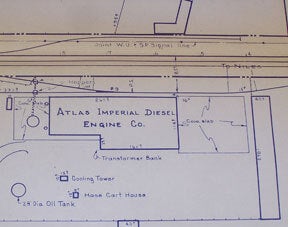
Station Plan of Hayward, Alameda County, California. Map
Southern Pacific Lines (San Francisco, Calif.) · 1950 · Wittenborn Art Books
$350.00 (€317.55 | £264.92 | ¥55,873)
San Francisco, Calif.: Southern Pacific Company, 1950. Map. Blueline print 24" x 56", notes indicate "Sheet 1 of 3." Includes Southern Pacific and Western Union Lines, Hathaway Ave, Meekland Ave, Atlas Imperial Diesel Engine Co. Map primarily consists of signs and measurements...

Map of Martinez, California with Street Index
Southern Pacific Lines (San Francisco, Calif.) · 1750 · Wittenborn Art Books
$225.00 (€204.14 | £170.31 | ¥35,918)
San Francisco, Calif.: Thomas Bros, [n.d.]. Map. Green on green print 11" x 9", Includes street index with approx 150 streets listed. Scale 1" = 1750'. Back side includes partial road map of Danville, Alamo, scale not listed. .

Station Plan of Eugene, Lane County, Oregon. One of Two. Map
Southern Pacific Lines (San Francisco, Calif.) · 1960 · Wittenborn Art Books
$350.00 (€317.55 | £264.92 | ¥55,873)
San Francisco, Calif.: Southern Pacific Company, 1960. Map. Blueline print 24" x 59" Pencil note indicates "Sh 1 of 2." From Emerald St in University Addition to Oak St. With Williamette River, Eugene Mill and Elevator Company, Pacific Highway. Scale 1" = 100'. .

Station Plan for Henderson, San Mateo County, California. Map
Southern Pacific Lines (San Francisco, Calif.) · 1962 · Wittenborn Art Books
$300.00 (€272.18 | £227.08 | ¥47,891)
San Francisco, Calif.: Southern Pacific Company, 1962. Map. Blueline print 24" x 83", From Belle Haven to Spring Valley Water Co. Includes Midway Supply and Salvage Co. Minimal details besides power lines and railroad line measurements and signs. Scale 1" = 100'. .

Station Plan for Hilt, Siskiyou County, California. Map
Southern Pacific Lines (San Francisco, Calif.) · 1956 · Wittenborn Art Books
$350.00 (€317.55 | £264.92 | ¥55,873)
San Francisco, Calif.: Southern Pacific Company, 1956. Map. Blueline print 24" x 56", Includes Fruit Growers Supply Co, F. G. S. Co Store and Office, Pond. Scale 1" = 100'. .

Switching Zone Map for Martinez - Antioch, California. Set of Twelve Sheets and Legend
Southern Pacific Lines (San Francisco, Calif.) · 1909 · Wittenborn Art Books
$225.00 (€204.14 | £170.31 | ¥35,918)
San Francisco, Calif.: Southern Pacific Company, 1909, reviewed 1961. Map. Set of thirteen blueline prints. Each approximately 13 x 55 inches. With multicolor lines indicating joint use of facilities by Southern Pacific Co. and Atchinson, Topeka and Santa Fe Railway Co. Scale ...

Station Plan of Fresno, San Joaquin County, California. Map
Southern Pacific Lines (San Francisco, Calif.) · 1946 · Wittenborn Art Books
$600.00 (€544.37 | £454.15 | ¥95,782)
San Francisco, Calif.: Southern Pacific Company, 1946. Map. Blueline print 24" x 220". Detailed map of Fresno along railroad lines, from Roeding Park to Atchison, Topeka, and Santa Fe building at California Ave and Belgravia Ave. Scale 1" = 100'. .

Station Plan of Giant - Sobrante, Contra Costa County, California. Map
Southern Pacific Lines (San Francisco, Calif.) · 1949 · Wittenborn Art Books
$250.00 (€226.82 | £189.23 | ¥39,909)
Oakland, Calif.: Southern Pacific Company, 1949, revised 1960. Map. Blueline print 24" x 53". Includes Western Union and Signal lines. Some buildings indicated in northeast corner, body of map is made up of measurements and signs along tracks. Scale 1" = 100'. .