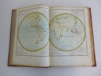
Clouet, Jean-Baptiste Louis (1729-1790) — Géographie Moderne Avec Une Introduction: Ouvrage Utile a Tous Ceux Qui Veulent Se Perfectionner Dans Cette Science, on Y Trouve Jusqu'Aux Notions Les Plus Simples Dont on a Facilité L'Intelligence Par Des Figures Pour le Mettre a la Portée de Tout le Monde, Chaque Carte a Sur Les Marges L'Explication de Ce Qu'Elle Renferme, la Méthode Qu'on Y Suit a Pour Objet de Developper Les Connoissances Qui Tiennent a L'Histoire, Ce Qui Rend Cette Géographie Tres Interessante. Dediée a Messieurs de L'Acade
Paris: Mondhare, 1780. Folio. 28.5 x 41 cm. New goatskin and marbled boards by the artisan binder Sasha Mosalov. Lacking Plate 1 (La Sphere) with the other 67 plates present. Contemporary handcoloring on the 67 double page maps; pages on hinges. Blank corners of a few pages repaired .. pôles, Équateur, zones torrides, climats, positions des peuples, systèmes du monde, mappemonde, rose des vents et cartes : Europe (3), Asie (3), Amérique (3), Afrique (3), France (7), etc..OCLC Number / Unique Identifier: 1403814380. References: P661; Moreland & Bannister p.138 School Atlas. This is an unusually thorough teaching atlas for the period: each map has marginal text on both sides which explains the function of the map - topographical, historical, political, etc. Because of its comprehensiveness, this atlas must have been used by advanced students of geography. Editions were published in 1767, 1780, 1787, 1791, 1793. Clouet also published a set of wall maps of the Continents between 1776 and 1793. Full color. Covers are purple marbled paper covered boards with a new leather spine stamped with the title "Clouet Atlas" in gilt.......Jean-Baptiste Louis Clouet (1729-1790) was a mapmaker with premises in both Paris and Cadiz. He was eventually named Royal Geographer of the Academie des Sciences de Rouen. Although he made several lavish wall maps, he is best known for Geographie Moderne (1776-93). .