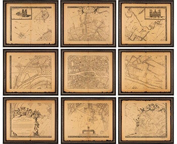
Rochefort , Albert Jouvin de (1640-1710) After; Alfred Bonnardot (1808 - 1884), text — Paris Vers 1675. Grand Plan de Paris Et de Ses Environs. Older Facsimile
Paris: A. Taride, circa 1908. Nine panels each measuring, 25" x 21", which are reissued copies of Albert Jouvin de Rochefort's nine-panel map of Paris, originally printed in 1675. Rochefort's highly detailed map shows key buildings, streets, farms, etc. A total of nine panels, that together form a single map of Paris as it was in 1675. There are vignettes in the top two corner panels, which show the Hotel de Ville and Notre Dame, and large cartouches, and dedications in the lower two corner panels. The dedication is to French diplomat, Simon Arnauld. Each of the panels has been framed to the overall size of 28.5" x 24". Accompanying the framed map sections is the original cover wraps, measuring 13" x 21.5", with a title and decorative border. This has also been framed, measuring 16.25" x 24.75" overall.. Albert Jouvin de Rochefort (1640-1710) was a French cartographer who also served from 1675-1702 as Treasurer to Louis XIV of France. His nine-panel map of Paris, entitled Paris et ses Environs, was published in 1672-1675..OCLC Number / Unique Identifier: 921906005: 3 pages : 1 map ; (135 x 165 cm) on 9 sheets each 54 x 66 cm folded to 54 x 33 cm. .